
NEWS
Miao Tieh Precision Industrial Collaborates with NSPO on Triton Satellite Propulsion Experimental Module
March 01,2023

Taiwan’s Domestically Developed “Hunting Wind” Satellite Fully Assembled, Expected to Reach Launch Readiness by Year-End
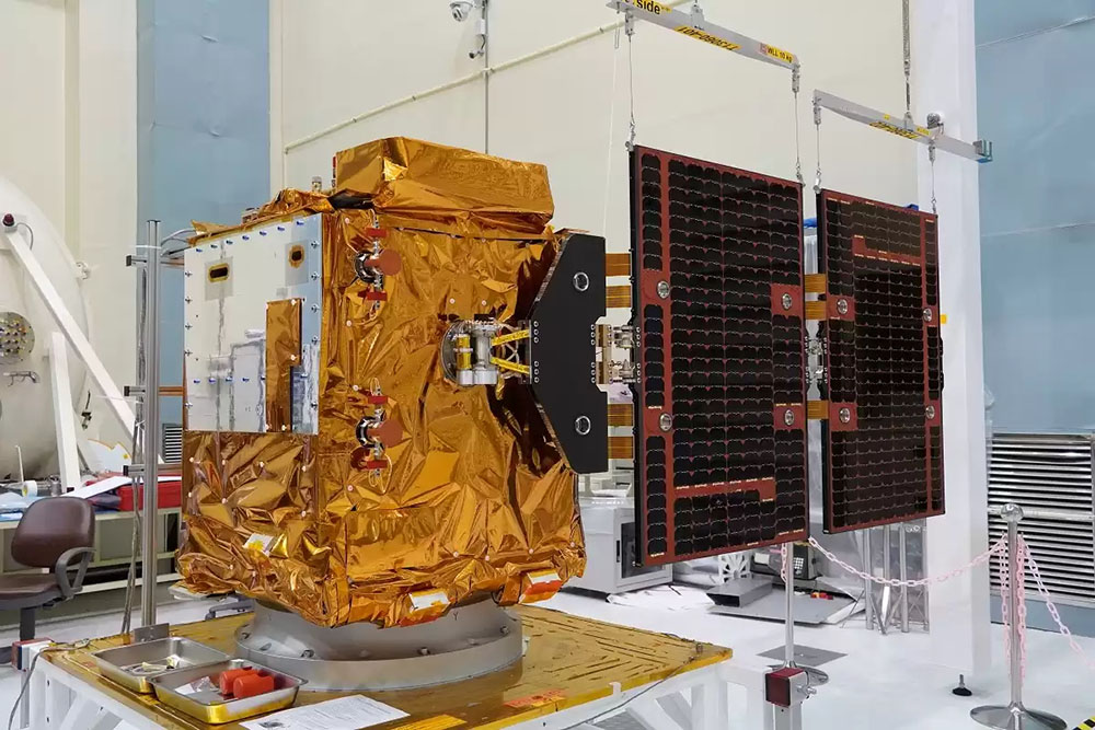
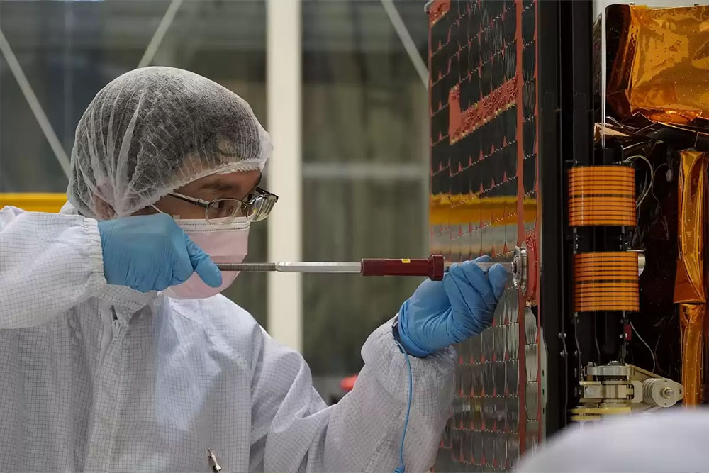
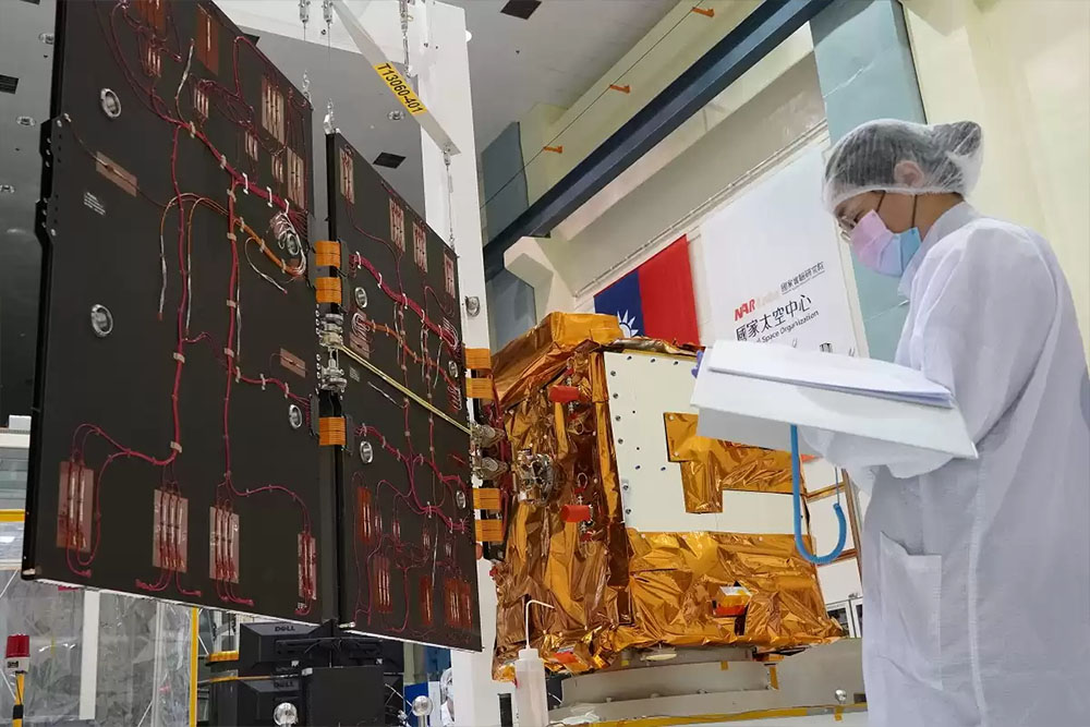
The “Hunting Wind TRITON” (FORMOSAT-7R) satellite, independently developed by the National Space Organization (NSPO) under the National Applied Research Laboratories of the Ministry of Science and Technology, has recently completed its final assembly milestone with the installation of its solar panels. With the full assembly now completed, the satellite will undergo a series of environmental and functional tests. It is expected to reach launch readiness by the end of this year, with the earliest possible launch scheduled for the first quarter of next year aboard an Arianespace VEGA C launch vehicle from the Guiana Space Centre in French Guiana.
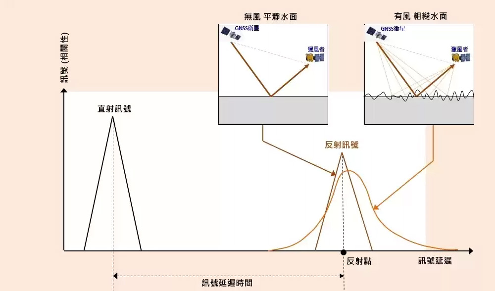
The Hunting Wind satellite is designed for wind field observation and was originally an autonomous satellite under the FORMOSAT-7 program (FORMOSAT-7R). Following mission adjustments, it was officially named “Hunting Wind.” Unlike FORMOSAT-7, which directly observes signals transmitted by Global Navigation Satellite Systems (GNSS), such as GPS and GLONASS, after they are refracted through the ionosphere and atmosphere, Hunting Wind is equipped with a domestically developed Global Navigation Satellite System Reflectometry (GNSS-R) receiver. Operating in low Earth orbit, it collects GNSS signals reflected from the ocean surface and uses the physical characteristics of these reflected signals to estimate ocean surface wind speedsii.
Hunting Wind is the second satellite fully developed in Taiwan, following FORMOSAT-5. A total of 82% of the satellite, including its payload, was developed and manufactured domestically. When ground systems are included, more than 20 Taiwanese research institutions and companiesiii participated in the project. After launch, the satellite will also validate 10 key components and technologiesiv that were independently designed and manufactured in Taiwan.
The name “Hunting Wind” was selected through a public naming process, while its English name, “TRITON,” is derived from Greek mythology. In mythology, Triton is the son of Poseidon, the god of the sea. In addition to wielding Poseidon’s symbolic trident, Triton carries a conch shell, which he blows when traveling, stirring up winds and waves, symbolizing his ability to control wind and seas.
Minister of Science and Technology Wu Tsung-tsong stated that the Hunting Wind satellite builds upon the experience gained from FORMOSAT-5 while further increasing the proportion of domestically manufactured components. Key elements—including the satellite computer, power control system, fiber optic gyroscope, navigation receiver, and critical payload instruments—are all made in Taiwan. The Space Center has also developed multiple key technologies, demonstrating that Taiwan now possesses comprehensive satellite development capabilities. Combined with Taiwan’s already mature ground systems and related technologies, Taiwan will not be absent from the global low Earth orbit satellite wave.
Wu Jong-shinn, Director General of the National Space Organization, pointed out that the domestically developed GNSS-R instrument utilizes proprietary technologies for firmware optimization and can simultaneously receive up to eight data channels. In the East Asian region, it can also receive reflected signals from Japan’s Quasi-Zenith Satellite System (QZSS), offering performance superior to comparable foreign instruments. Furthermore, data processing and application technologies were jointly developed by the Space Center, National Central University, National Cheng Kung University, and the Central Weather Administration, significantly enhancing the practical applications of the data.
Project Manager Lin Chen-tsung noted that after the installation of the solar panels, the fully assembled satellite will undergo a series of tests, including mass property measurements, vibration tests, acoustic tests, shock separation tests, and final full-system functional verification. Once all tests are completed and the satellite passes the pre-shipment review, it will be deemed launch-ready and transported to French Guiana.
Operating in an orbit at an altitude of approximately 550 to 650 kilometers, the Hunting Wind satellite will receive GPS and GLONASS signals reflected from the ocean surface. The derived ocean surface wind field data represent one of the most critically lacking types of meteorological data. When combined with high-resolution coastal wind field data from ground-based radar, these observations can be applied to typhoon track forecasting, heavy rainfall prediction, and air pollution modeling, as well as research into ocean–atmosphere interactions. As such, Hunting Wind serves as both a meteorological satellite and a scientific research satellite.
The “Hunting Wind TRITON” (FORMOSAT-7R) satellite, independently developed by the National Space Organization (NSPO) under the National Applied Research Laboratories of the Ministry of Science and Technology, has recently completed its final assembly milestone with the installation of its solar panels. With the full assembly now completed, the satellite will undergo a series of environmental and functional tests. It is expected to reach launch readiness by the end of this year, with the earliest possible launch scheduled for the first quarter of next year aboard an Arianespace VEGA C launch vehicle from the Guiana Space Centre in French Guiana.
The Hunting Wind satellite is designed for wind field observation and was originally an autonomous satellite under the FORMOSAT-7 program (FORMOSAT-7R). Following mission adjustments, it was officially named “Hunting Wind.” Unlike FORMOSAT-7, which directly observes signals transmitted by Global Navigation Satellite Systems (GNSS), such as GPS and GLONASS, after they are refracted through the ionosphere and atmosphere, Hunting Wind is equipped with a domestically developed Global Navigation Satellite System Reflectometry (GNSS-R) receiver. Operating in low Earth orbit, it collects GNSS signals reflected from the ocean surface and uses the physical characteristics of these reflected signals to estimate ocean surface wind speedsii.
Hunting Wind is the second satellite fully developed in Taiwan, following FORMOSAT-5. A total of 82% of the satellite, including its payload, was developed and manufactured domestically. When ground systems are included, more than 20 Taiwanese research institutions and companiesiii participated in the project. After launch, the satellite will also validate 10 key components and technologiesiv that were independently designed and manufactured in Taiwan.
The name “Hunting Wind” was selected through a public naming process, while its English name, “TRITON,” is derived from Greek mythology. In mythology, Triton is the son of Poseidon, the god of the sea. In addition to wielding Poseidon’s symbolic trident, Triton carries a conch shell, which he blows when traveling, stirring up winds and waves, symbolizing his ability to control wind and seas.
Minister of Science and Technology Wu Tsung-tsong stated that the Hunting Wind satellite builds upon the experience gained from FORMOSAT-5 while further increasing the proportion of domestically manufactured components. Key elements—including the satellite computer, power control system, fiber optic gyroscope, navigation receiver, and critical payload instruments—are all made in Taiwan. The Space Center has also developed multiple key technologies, demonstrating that Taiwan now possesses comprehensive satellite development capabilities. Combined with Taiwan’s already mature ground systems and related technologies, Taiwan will not be absent from the global low Earth orbit satellite wave.
Wu Jong-shinn, Director General of the National Space Organization, pointed out that the domestically developed GNSS-R instrument utilizes proprietary technologies for firmware optimization and can simultaneously receive up to eight data channels. In the East Asian region, it can also receive reflected signals from Japan’s Quasi-Zenith Satellite System (QZSS), offering performance superior to comparable foreign instruments. Furthermore, data processing and application technologies were jointly developed by the Space Center, National Central University, National Cheng Kung University, and the Central Weather Administration, significantly enhancing the practical applications of the data.
Project Manager Lin Chen-tsung noted that after the installation of the solar panels, the fully assembled satellite will undergo a series of tests, including mass property measurements, vibration tests, acoustic tests, shock separation tests, and final full-system functional verification. Once all tests are completed and the satellite passes the pre-shipment review, it will be deemed launch-ready and transported to French Guiana.
Operating in an orbit at an altitude of approximately 550 to 650 kilometers, the Hunting Wind satellite will receive GPS and GLONASS signals reflected from the ocean surface. The derived ocean surface wind field data represent one of the most critically lacking types of meteorological data. When combined with high-resolution coastal wind field data from ground-based radar, these observations can be applied to typhoon track forecasting, heavy rainfall prediction, and air pollution modeling, as well as research into ocean–atmosphere interactions. As such, Hunting Wind serves as both a meteorological satellite and a scientific research satellite.
1. Characteristics of the Hunting Wind Satellite
| Item | Description |
|---|---|
| Configuration | Cubic structure with solar panels mounted on one side |
| Dimensions | 1.0 m × 1.2 m × 1.25 m (3.5 m in length after solar panels are deployed) |
| Total Mass | Approximately 250 kg |
| Orbit | 550–650 km altitude, inclination 97.66° |
| Mission Lifetime | 5 years |
| Indigenous Payload | Global Navigation Satellite System Reflectometry (GNSS-R) receiver, capable of simultaneously receiving 8 data channels, outperforming existing international instruments which typically support only 4 channels |
2. Application of Sea-Surface Reflected Satellite Signals in Wind Speed Retrieval
When electromagnetic signals transmitted by Global Navigation Satellite Systems (GNSS), such as GPS and GLONASS, are reflected off the ocean surface and received by the Hunting Wind satellite, variations in sea surface roughness—greater roughness under strong winds, similar to a worn copper mirror, and lower roughness under calm conditions, resembling a smooth copper mirror—result in differences in the received signal characteristics, including signal strength and time delay. These variations can be used to retrieve the corresponding ocean surface wind speed.
3. More Than 20 Taiwanese R&D Institutions and Companies Participated in This Project
| Item | Participating Organizations |
|---|---|
| Satellite Computer | National Chung-Shan Institute of Science and Technology (NCSIST) |
| Power Control Unit | National Chung-Shan Institute of Science and Technology (NCSIST) |
| S-band Antenna and Filter | Fong Hsing Technology |
| Fiber Optic Gyroscope | NCSIST, Trivision Fiber Optics, Xin Hao Technology |
| GPS Navigation Receiver | Industrial Technology Research Institute (ITRI), MegaLink Technology, Sinpro Technology, Advanced Semiconductor Engineering (ASE), National Cheng Kung University |
| Propulsion Experiment Module | Kung Chun Precision, Yung Sheng Steel, Taiwan Silicon Microelectronics, Sheng Xin Machinery, Yu Chang Electric, Yi Material Technology, Meng Jin Technology, Miao Tieh Precision Industrial, Zhan Jie Industrial, Mei Hsun Enterprise |
| Satellite Structure | Aerospace Industrial Development Corporation (AIDC) |
| GNSS-R Low-Noise Amplifier | Industrial Technology Research Institute (ITRI) |
| Mechanical Ground Support Test System | Aerospace Industrial Development Corporation (AIDC) |
| Ground Satellite Control Center | Syscom Computer Engineering, NewType Information System, GrandTech Systems, Flowring Technology |
| Other Services | Taiwan Fire & Marine Insurance, Fubon Insurance |
| Data Processing, Services, and Application Technologies | Central Weather Administration, National Central University, National Cheng Kung University |
4. Ten Key Components and Technologies Independently Designed and Manufactured in Taiwan
| Item | Description |
|---|---|
| Key Components | Satellite computer, power control unit, GPS navigation receiver, fiber optic gyroscope, propulsion experiment module |
| Key Technologies | Micro-stepping solar array drive, maximum power point tracking (MPPT), integrated star tracker and gyroscope attitude determination system, gyro-less attitude determination system, data relay technology |
Source: National Applied Research Laboratories (NARLabs)